10 Day Southwest Road Trip Itinerary: Zion, Antelope Canyon, White Pocket, Monument Valley & Canyonlands
A Las Vegas Loop Road Trip Through Three States
If there is one road trip that belongs on every American's bucket list — and consistently tops most international visitors' USA plans — it's a loop through the American Southwest. Red rock canyons, slot canyon light beams, ancient Navajo lands, towering mesas: it's all here, and it's all extraordinary.
This 10 day Southwest road trip itinerary starts and ends in Las Vegas, covers three states (Nevada, Utah, and Arizona), visits nine parks and monuments, and mixes some of the most iconic landscapes in North America with a handful of gems that most visitors never find — most notably White Pocket, a place that photographers who've experienced both it and The Wave call equally spectacular.
Some posts on this site contain affiliate links, meaning if you book or buy something through one of these links, I may earn a small commission (at no extra cost to you!). Opinions are always my own and I’ll never promote something I don’t use or believe in. Also as an Amazon Associate I earn from qualifying purchases.
A quick note on what this itinerary is and is not: this is a photography-focused, crowd-avoiding road trip through the Southwest. It deliberately skips the Grand Canyon (see the callout below) and Bryce Canyon (an alternate routing option is available at the end if you want to add either). It does include Zion, Antelope Canyon, Monument Valley, Canyonlands, and several places you've almost certainly never heard of. That's very much intentional.
We've been roaming the Southwest for years — first as a 10-day scouting trip in 2012, then back for specific parks and Grand Staircase-Escalante camping, then 18 months in an RV based largely in the region, then two years living in Phoenix to fill in the gaps. What you're reading is the distillation of all of that experience.

Trip at a Glance
- Total driving distance: ~1,832 miles across 10 days
- States: Nevada, Arizona, Utah
- Parks & Monuments Visited: 9
- Fly in/Fly out: LAS (Las Vegas)
The 10-Day Itinerary at a Glance
|
DAY
|
ROUTE
|
HIGHLIGHT
|
MILES |
STAY |
|---|---|---|---|---|
|
1 |
Las Vegas to Zion |
Drive & settle in Springdale |
176 |
|
|
2 |
Zion |
Zion-Mt. Carmel Road, Canyon Overlook Trail, Kolob Terrace |
Less than 50 |
Desert Pearl Inn |
|
3 |
Zion to Page |
Sunrise at Zion, Horseshoe Bend, Colorado River float |
104 |
|
|
4 |
Page |
Antelope Canyon photographer's tour, Navajo Bridge |
Local |
Courtyard Page |
|
5 |
Page to Kanab area and back |
White Pocket, South Coyote Buttes |
~150 |
Courtyard Page |
|
6 |
Page to Kanab area and back |
Grand Staircase-Escalante photography tour |
~150 |
Courtyard Page |
|
7 |
Page to Monument Valley |
Forrest Gump Point, Hunts Mesa sunset tour |
122 |
|
|
8 |
Monument Valley to Moab |
Valley of the Gods drive, Sorrel River Ranch |
176 |
|
|
9 |
Moab |
Canyonlands National Park |
50 |
Sorrel River Ranch |
|
10 |
Moab to Las Vegas |
Long drive home, overnight Las Vegas |
490 |
What About the Grand Canyon?
You'll notice this itinerary doesn't include the Grand Canyon — and that's deliberate. The Canyon deserves its own dedicated trip; squeezing it into a fast-moving road trip does it no justice. If it's non-negotiable for you, see the Alternate Routes section at the end of this post. For this trip, we traded Grand Canyon time for White Pocket — a place that photographers who have seen both call equally, if not more, spectacular.
Best Time to Do This Southwest Road Trip
Having lived in the Southwest for two years, we experienced all the seasons. For the most part, you do NOT want to visit in the summer. The heat is no joke, and there are a lot of summertime tourists from around the world, so national parks on your itinerary can be quite crowded. Spring (April-May) is our top pick.
Spring (April-May) — Our top pick. Temperatures sit in the 60s-80s F, wildflowers bloom across Zion and the Utah plateaus, and the crowds haven't yet hit summer peaks. This itinerary was originally done in May.
Fall (September-October) — A very close second. Temperatures drop to a comfortable level after summer's extremes, and the golden-hour light for photography is extraordinary.
Summer (June-August) — Avoid if possible. Temperatures in Page and Monument Valley regularly exceed 105°F. Afternoon monsoons can close dirt roads to White Pocket without warning, and Zion's shuttle lines can have 90-minute waits.
Winter (November-March) — Possible, but challenging. Some roads to White Pocket may be impassable. Zion in snow is stunning and uncrowded, but check road conditions before committing to off-road days.
National Park Pass — Required
America the Beautiful Annual Pass: $80/year for US residents. Starting in 2026, the pass costs $250/year for non-US residents, with some parks charging an additional $100/person surcharge. Buy at the gate of your first park or in advance. It covers all national parks and federal recreation sites, and it pays for itself with two parks.
Day 1: Las Vegas to Zion
On Day 1, we flew into Las Vegas in the morning. First stop before leaving the city: Whole Foods at 6689 S Las Vegas Blvd — just 7 minutes from the airport. Don't skip this. Given how remote the next several days become, stocking up on groceries is one of the best decisions you will make for the trip.
We loaded up on water and coconut water (desert hydration is not optional), non-perishables like olives and artichoke hearts, fresh fruit and vegetables for the first few days, instant miso, oatmeal, tea, and instant coffee packets. We brought an electric kettle from home. And yes, wine — dramatically cheaper from a store than from any restaurant. We grabbed lunch from the salad bar and hit the road.
The 3-hour, 169-mile drive took us through parts of Nevada, Arizona, and Utah, skirting the Virgin River through surprisingly lush green valleys before opening into a more dramatically desert landscape. One of the genuine pleasures of Nevada: the 85 mph speed limit.
Our destination was Springdale, Utah — a tidy, charming little town at the foot of Zion National Park that reminds me of Sedona: clean, well-organized, beautiful even without a national park backdrop.
We stayed at the Desert Pearl Inn for two nights. The rooms have a rustic-luxury log-cabin feel, each with a mini-kitchen, generous bathroom, and a terrace perfect for evening wine as the canyon walls cool in the dusk.
Critical tip: Request a canyon-view room, not a pool-facing room. The pool is beautiful, but the canyon walls are something else.
Since you cannot drive a private vehicle into the main section of Zion, the park shuttle system is your main mode of transport. Most hotels are along Zion Park Blvd with shuttle stops nearby.
Day 2: Zion National Park
We woke at 5:30 a.m. to catch the first shuttle, then walked back to the hotel and got the car instead. That's us: constitutionally unable to share a shuttle with large crowds at sunrise. We drove to the Zion Canyon Visitor Center area and hiked behind the museum to a large meadow with an unobstructed view of the canyon walls as they lit up in the morning glow.
From there, we drove the Zion-Mt. Carmel Road, stopping constantly. The Zion-Mt. Carmel Tunnel is a genuinely odd piece of engineering — you can't stop inside, but you can photograph the carved windows from the road below with a good telephoto lens.
On the other side of the tunnel, we hiked the Canyon Overlook Trail — a moderate-difficulty path that takes about an hour, with excellent canyon views, interesting rock textures, and, in spring, a carpet of wildflowers, including the Sego Lily, Utah's state flower. Highly recommended.
| | |
After a picnic lunch at Mt. Carmel Junction, we drove to Kolob Terrace — a 21-mile drive to Lava Point that the vast majority of Zion visitors never find. The views from the Colorado Plateau lookout are remarkable: Zion Canyon, Bryce Canyon, Pink Cliffs, and the Kaibab Plateau are all visible at once on a clear day.
| | |
We spent nine hours exploring Zion and didn't hike Angels Landing, didn't do the Narrows, and didn't see the Subway. We enjoyed Zion entirely on our own terms and at our own pace.
Additional reading: Things to do while staying near Zion National Park
2026 Planning Note
Angels Landing now requires a permit ($6/person) obtained through a recreation.gov lottery. Permits for the busy season sell out quickly. Enter the lottery in advance if this iconic hike is on your list. No permit is needed for Canyon Overlook Trail or Kolob Terrace.
Easy day tours that you can do while visiting Zion National Park:
- From Springdale: Zion National Park Scenic Hiking Tour
- East Zion: 1-Hour Checkerboard Overlook Jeep Tour
- East Zion: Slot Canyon Exploration and UTV Tour
Day 3: Zion to Page — with a Stop at Horseshoe Bend
We woke at 5:30 a.m. again (sunrise photography is not for people who value sleep) and made it to the museum meadow in time for the full canyon sunrise. Peaceful, cold, and absolutely worth it. Rock climbers were already on the walls.
After a final pass along the Zion-Mt. Carmel Road, we pointed the car south toward Page, Arizona, where we'd be based for the next four nights.
Horseshoe Bend — Don't Skip It
Page, Arizona, is about 90 minutes from Zion, so you have time to stop at Horseshoe Bend before checking in. The Colorado River carves a near-perfect horseshoe through the canyon below, and the view from the rim is genuinely jaw-dropping. It's a 0.75-mile walk from the parking lot ($10 to park) on Highway 89, a few miles south of Page. No guide, no tour, no reservation required. But due to its Instagram fame, it can be very crowded!
Photography Tips for Horseshoe Bend
- Best light: Sunrise or early morning for soft light and minimal crowds. Late afternoon/sunset is beautiful, but the overlook gets very busy.
- Lens: Wide-angle (24mm or wider) to capture the full sweep of the bend.
- Safety: Most viewpoint edges have no guardrails. Watch your footing and keep children close.
- Crowds: Visit on a weekday or arrive before 8 a.m. to have the rim largely to yourself.
We arrived in Page around midday, grabbed lunch at Denny's (we would end up eating three breakfasts there over four days — a fact that still astonishes me, as it had been a decade since my last Denny's visit), and checked into the Courtyard Marriott, our base for the next four nights.
Page is one of the largest towns in a three-hour radius, which is precisely why it makes such a good base. There is a Walmart and a Safeway. Use Walmart for food; I waited 45 minutes for two deli sandwiches at the Safeway and have never fully recovered. But Safeway has a Starbucks…
In the afternoon, we headed to the Colorado River Discovery tour office for our pontoon float below Glen Canyon Dam. “River rafting” slightly oversells what is essentially a very scenic float — the rapids don't start until Lee's Ferry at the end of the tour. But floating through 15 miles of turquoise river flanked by 800-foot canyon walls, guided by someone with genuinely good dam and river history, is a lovely afternoon.
| |
Tips for the Glen Canyon Dam River Tour
- No shade on the boat or at the two beach stops, you are fully exposed to the sun the entire time
- Water temperature is 45 F year-round; swimming is for the enthusiastic only
- It's a 90-minute bus ride back to Page from Lee's Ferry — bring a snack
- We used Colorado River Discovery and were very happy with them; read reviews for any company you choose
| | |
Here's a similar tour: Glen Canyon and Horseshoe Bend Raft Trip
Day 4: Antelope Canyon
Day 4 was a small luxury: the first morning since leaving Las Vegas that we didn't need to get up at 5 a.m.
Before heading to Antelope Canyon, we drove to the Navajo Bridge over Marble Canyon, one of only two crossings over the Colorado River for hundreds of miles. There are two bridges side by side: the original pedestrian bridge and a wider replacement. Standing on the old bridge looking down into Marble Canyon is quietly spectacular, and this is a good spot for a rare California Condor sighting.
Then to our main event: an Antelope Canyon photographer's tour with Antelope Canyon Tours, a Navajo-run company. We chose a Navajo-operated company deliberately — they have the deepest knowledge of the site and the best access.
Antelope Canyon is a narrow slot canyon with towering walls of swirling sandstone in shades of orange, red, and gold, lit by shafts of light filtering through openings in the rock above. It looks like another planet. It is also extremely popular, which is why your choice of tour matters enormously.
Photographer's Tour vs. Regular Tour
Book the Photographer's Tour, not the standard tour, if photography is your goal. The extra cost gets you right-of-way over other tour groups, a guide who sets up shots and keeps the path clear, and more time at the best light spots. On a regular tour, you'll be competing with hundreds of people for a few rushed seconds at each viewpoint.
| | |
Essential tips:
- A tripod is mandatory — this is a low-light environment
- Choose your lens before you go; no space to change lenses inside the canyon, and you will expose your lens to dust
- Leave your bag in the car. Camera, tripod, water bottle. Nothing else.
- First and last tours of the day have fewer people and better light
2026 Planning Note
Antelope Canyon tours now sell out 6-9 months in advance for summer visits. For spring and fall, book at minimum 3 months out. Book through official Navajo-run companies.
Similar Antelope Canyon Tours:
- Antelope Canyon: Canyon X, Upper, or Lower Antelope Entry
- From Flagstaff: Antelope Canyon and Horseshoe Bend
- From Sedona or Flagstaff: Horseshoe Bend & Antelope Canyon X Tour
We left Antelope Canyon dusty, hungry, and genuinely awed, and headed to Big John's Texas BBQ for an early dinner. Outdoor seating, excellent barbecue, perfect post-canyon atmosphere.
Page has grown so much in the time since I have been visiting! There are new hotels, RV parks, and Airbnbs right at the center of all the fantastic outdoor activities (including an annual balloon festival)!
Day 5: White Pocket & South Coyote Buttes
Day 5 was one of the most memorable of the entire trip, partly because we went to an extraordinary place, and partly because it wasn't the one we'd originally planned.
The Wave Lottery — 2026 Update
The in-person lottery at the BLM office in Kanab that I originally described in this post no longer exists. The process is now entirely online through recreation.gov, and works as follows:
How to Enter The Wave Lottery (2026)
- Advance lottery: Opens 4 months before your desired date. Results announced approximately 1 week later. Apply at recreation.gov.
- Day-before lottery: Opens at midnight Mountain Time the night before your desired date. Results by 10 a.m. the morning before. Also at recreation.gov.
- Quota: 64 people per day total. Only 10 slots go to the day-before lottery, so advance applications give better odds.
- Pro tip: Enter both lotteries on every date you're flexible for. Having a backup plan is essential; White Pocket is ours.
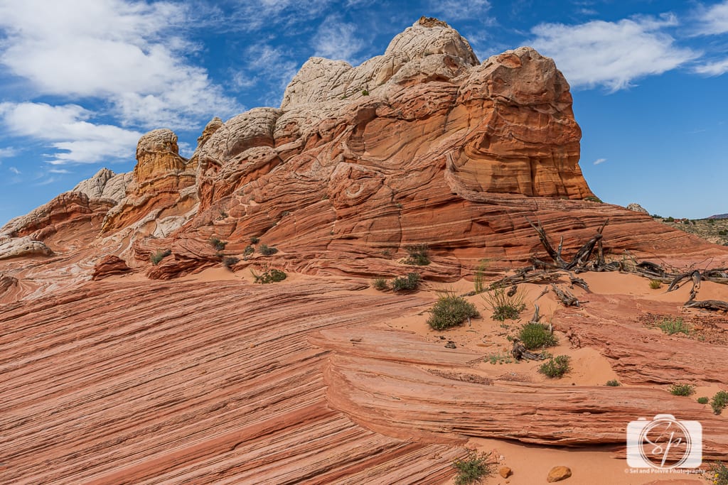
White Pocket — The Real Star of Day 5
White Pocket is a rock formation in the Vermilion Cliffs National Monument area, reached via roads so rough and sandy that attempting to drive yourself without a serious 4WD vehicle and local knowledge is genuinely dangerous. Hire a guide.
Our guide from Dreamland Safari Tours, who had spent his entire life in this landscape, entertained us with stories on the drive out. When we arrived at White Pocket, we were in complete awe. The formations look like nothing I've seen elsewhere — swirling, brain-textured rock in white, red, and ochre, as if the earth had been stirred into a marble cake and then petrified. We photographed for several hours, and it still wasn't enough.
Read more: White Pocket Arizona – Guide to the Best Wave Alternative
People who have seen both White Pocket and The Wave consistently say White Pocket is just as spectacular. Having been to both, I believe them. The fact that it's accessible every day, unlike The Wave, makes it even more appealing.
Cottonwood Cove — South Coyote Buttes
After White Pocket, our guide drove us to Cottonwood Cove in the South Coyote Buttes. The walk is longer, in sand, in heat, after an already full morning, but worth it. The rock fins here are extraordinary: vertical and horizontal layers jutting from the ground like architectural experiments left unfinished by something very old.
Tips for White Pocket & South Coyote Buttes
- Hire a guide for White Pocket. Non-negotiable. The sandy roads will strand a standard vehicle.
- You need a permit for Coyote Buttes South (recreation.gov). Guided tour operators usually hold blanket permits.
- If you're a serious photographer, spend the full day at White Pocket rather than splitting with Cottonwood Cove.
- Water. More than you think. The desert will take everything you have.
Day 6: Grand Staircase-Escalante Photography Tour
By Day 6, the cumulative effect of early mornings and desert heat was catching up with me. But we had another full-day photography tour booked with Dreamland Safari Tours—this time through Grand Staircase-Escalante National Monument —and I rallied.
Grand Staircase-Escalante is an “area” rather than a single site — nearly 2 million acres of protected land on the Arizona-Utah border. Most visitors drive straight past it on the way to Bryce Canyon or Zion. That's a mistake.
We started in Johnson Canyon, where ancient Anasazi sites give way to homesteads from founding Mormon families, some of whose descendants still hold the land. Then to Willis Creek Trailhead for a slot canyon hike along the river — a gentler, more accessible slot canyon than Antelope, beautiful, and at your own pace.
After lunch (which our guide had laid out while we were hiking — one of the small joys of having a good guide), we drove to Kodachrome Basin State Park — named by a 1949 National Geographic expedition — where we spotted pronghorn antelope grazing on Sego Lilies, the same flowers I'd been photographing in Zion.
Then along Candy Lane on Cottonwood Road to Cottonwood Narrows North, where fossilized clams and oysters embedded in the Dakota Formation have sat for 100 million years. I touched them and felt appropriately small.
Our guide's final insistence of the day: a 1-mile hike in sand to the Hoodoo Overlook at Rim Rock. I was nearly spent and almost skipped it. He wouldn't hear of it. The view was worth every step.
Day 7: Monument Valley
Day 7 felt more like a normal person's travel day — we slept in slightly, ate breakfast sitting down before leaving, and had a proper morning for the first time in a week.
Monument Valley sits entirely on Navajo Nation land. Our base for the night was The View Hotel, essentially the only hotel on the reservation, though they've since added cabins. You are paying for the view, which is genuinely extraordinary: all rooms face the same direction, overlooking the Mittens and the valley beyond. One restaurant on the property, so come with your own food if you're particular about meals.
There are a few more accommodation options in Monument Valley these days, including Goulding's Lodge & Campground (which has a store, gas station, and private land you can access to see some of the monuments), as well as private homes or rooms in the area. We have also camped with our Tepui tent at the KOA Monument Valley.
In the late afternoon, we met our guide from Monument Valley Safari for a 7-hour tour up to Hunts Mesa for the sunset. At the top, while we waited for the sun to drop below the horizon, our guide played a traditional Navajo instrument and sang. It was one of those moments that make a trip.
The drive back down in the dark was an experience I won't soon forget. Nerve-racking, completely dark, absolutely thrilling.
Forrest Gump Point
On US-163, about 20 minutes north of the Monument Valley Visitor Center, is the stretch of road where Forrest Gump announced he was tired and turned around. The framing of the road with Monument Valley's mesas behind it is one of the most recognizable vistas in American cinema. Pull over, take the shot, feel the strange joy of recognizing a movie location in real life. GPS: 37.101393, -109.990973.
Tips for Monument Valley
- 18+ companies run tours here — read reviews carefully and book the guides with the best ratings, not the lowest price
- The self-drive Valley Drive (17 miles, unpaved) is accessible without a guide for an afternoon
- Sunrise and sunset are when Monument Valley earns its reputation. Stay for at least one.
- Goulding's Lodge is an alternative accommodation option with its own store and gas station
Monument Valley Tours:
- We LOVE sunrises, so this is our favorite!
- We did an amazing sunset tour as well!
- Monument Valley: Scenic 1.5-Hour Tour
- Monument Valley: 2.5-Hour Tour with Backcountry Access
- Monument Valley: Scenic 2.5-Hour Backcountry Tour
- Monument Valley: 3.5 Hour Extended Tour & Backcountry Access
Day 8: Monument Valley to Moab — via Valley of the Gods
Day 8 was a travel day with one spectacular detour. We slept in, had a picnic breakfast watching the mesas, and hit the road.
Valley of the Gods
On the way to Moab, we took Highway 261 through the Valley of the Gods — Monument Valley's quieter, free, self-guided cousin. Similar rock formations: buttes, mesas, spires in red and ochre. No entrance fee, no crowds, no tour requirement. We spent an hour driving the unpaved route, windows down, making up names for the formations. The one that looks like an Indian chief is my personal favorite.
Then onward to Moab — a proper town with restaurants, grocery stores, even a Starbucks, which felt almost surreal after days of Denny's and desert picnics. Our destination was Sorrel River Ranch, 30 minutes out on Highway 128 along the Colorado River at mile marker 17.
We stopped at Castle Creek Winery on the way for wine and cheese provisions, set up an afternoon apero on our suite's porch overlooking the river, and genuinely decompressed for the first time in eight days. Room service steaks arrived. We were very happy.
Day 9: Canyonlands National Park
Rested, properly fed, and ready for one more day of desert.
We chose Canyonlands over Arches for crowd reasons — as we passed the Arches entrance road, we saw the line of cars stretching far back and congratulated ourselves extensively on this call.
The wind had other ideas. A sandstorm rolled in as we approached the park — the kind that turns the air orange and makes any camera lens a sacrifice. We managed to take some iPhone shots and spent much of the afternoon eating a picnic lunch in the car, watching dust columns move across the plateau. The park ranger said May was late for this kind of storm.
Canyonlands deserves more than a sandstorm day. On a clear visit — which we managed on a subsequent trip — it's a smaller, less crowded version of the Grand Canyon with spectacular rim viewpoints. Worth the return.
We retreated to the ranch for a movie, a nap, and then dinner in the restaurant. The farm-to-table concept is real (they do have a farm), and the craft beer elk sausage was genuinely good. A slight disconnect between the price point and the overall experience, but after ten days of picnics and Denny's, I may have been a demanding audience.
Tip: If you have a day to choose between Arches and Canyonlands, do Arches first — it's the more dramatic first impression. Canyonlands without crowds is a more meditative, expansive experience. Ideally, give yourself two days in Moab and do both.
Canyonlands + Arches Tours:
- From Moab: Full-Day Canyonlands and Arches 4×4 Driving Tour
- From Moab: Canyonlands National Park 4×4 White Rim Tour
- From Moab: Canyonlands Needle District 4×4 Tour
- From Moab: Arches National Park 4×4 Drive and Hiking Tour
Day 10: Moab to Las Vegas — The Long Drive Home
The long haul. Nearly 500 miles, mostly on fast, open desert highways — 80 mph in Utah, 75 in Nevada, wide blue skies, and cloud formations that deserve their own photographer.
We'd originally planned to fly home from Salt Lake City, but the one-way car drop fee more than doubled the rental cost. Driving back to Las Vegas with an extra hotel night and fuel cost significantly less. Worth checking for your own booking.
A Starbucks in St. George, Utah, was a genuine event after four days of instant coffee from an electric kettle. We lingered.
Our last night was at the Element Las Vegas — suite-style rooms that feel like apartments, with a full kitchen, proper space, and no casino floor to navigate. We used up the last of our grocery stash for dinner, repacked everything that had accumulated ten days of desert dust, and called it a trip.
This was our first Southwest road trip, and it sparked our 18-month RV adventure because we fell in love with the landscape and decided we wanted to see it all. There's still more to see. There always will be. Just start.
Alternate Route Options
Want to Add Bryce Canyon?
Bryce Canyon's amphitheater of hoodoos is unlike anything else in the Southwest. Two ways to slot it in:
Option A — Day 3 detour: Instead of driving directly from Zion to Page, head north from Zion to Bryce Canyon (about 2 hours), spend 3-4 hours hiking the Rim Trail and the Queen's Garden / Navajo Loop combination, then continue south and east to Page (another 2 hours). Longer driving day but completely doable with an early start.
Option B — Restructure Days 6-7: Finish your Escalante day in Kanab, spend the night near Bryce, spend the morning at Bryce Canyon, then continue to Monument Valley in the afternoon.
Use Kanab as a Second Base for White Pocket, Grand Staircase & South Coyote Buttes
In the main itinerary, we stay four nights in Page and do both the White Pocket / South Coyote Buttes day and the Grand Staircase-Escalante day from there. That works, but it means two long return drives of roughly 150 miles each. A cleaner alternative is to split that block: two nights in Page and two nights in Kanab.
Kanab is only about an hour from both White Pocket and the best Grand Staircase-Escalante entry points, compared to 1.5-2 hours from Page. It's a proper little town with good restaurants, a Subway and a couple of grocery options, and it sits right at the edge of Grand Staircase — so you're waking up inside the landscape rather than driving into it.
Alternate Schedule: 2 Nights Page + 2 Nights Kanab
- Day 3: Las Vegas / Zion -> Page. Horseshoe Bend stop en route. Check into Page (2 nights).
- Day 4: Antelope Canyon photographer's tour + Navajo Bridge. Based in Page.
- Day 5: Drive to Kanab (approx. 1.5 hrs). Check in. Afternoon walk around town or early dinner.
- Day 6: White Pocket + South Coyote Buttes with a Kanab-based guide. Much shorter drive than from Page.
- Day 7: Grand Staircase-Escalante photography tour from Kanab. End the day in Kanab before heading to Monument Valley the following morning.
This restructure adds one extra hotel transition but meaningfully reduces driving on both off-road days and gives you more time on-site. If Bryce Canyon is also on your list, Kanab is ideally placed—it's only 45 minutes from the Bryce Canyon entrance, so you can add a morning at Bryce on your way out to Monument Valley without it feeling rushed.
Good Kanab-based options include Best Friends Roadhouse and Mercantile, and Canyons Boutique Hotel. Both book up during peak season—add them to your planning checklist alongside Page.
Want to Add the Grand Canyon?
The Grand Canyon works best as a 1-2 day addition at the start of the trip, between Las Vegas and Zion. From Las Vegas, it's about 4 hours to the South Rim. Spend one night (book Grand Canyon lodges 4-6 months in advance), then continue to Zion the following morning via Desert View Drive. Alternatively, build a completely separate trip around the Grand Canyon — it deserves it.
Planning Checklist & Booking Lead Times
This is the most important practical section of the entire post. Some things need to be booked months in advance—don't let the trip fall apart because you waited too long.
4-6 Months Before (Book First)
- Antelope Canyon photography tour (summer travel: 6-9 months in advance)
- Monument Valley Hunts Mesa sunset/sunrise tour
- White Pocket / Dreamland Safari Tours
- Desert Pearl Inn, Springdale (Zion gateway fills up fast)
- The View Hotel, Monument Valley
- Sorrel River Ranch, Moab
2-4 Months Before
- Enter The Wave advance lottery on recreation.gov for any desired dates
- Courtyard Marriott Page
- Remaining accommodations along the route
- Glen Canyon Dam river tour (if you want a specific date)
Day Before / Day Of
- Enter The Wave day-before lottery at midnight MST on recreation.gov
- Check the Zion shuttle schedule and any timed-entry reservation requirements
- Check White Pocket road conditions (Dreamland Safari Tours can advise)
Frequently Asked Questions
How many miles is this 10-day Southwest road trip?
This itinerary covers approximately 1,832 miles of driving, plus around 500 additional miles in guided off-road vehicles. The single longest driving day is Day 10 (Moab to Las Vegas, 490 miles). Most other days are 100-180 miles.
Do I need a 4WD vehicle?
A high-clearance SUV is strongly recommended. For Days 5 and 6, you'll be in guided tour vehicles, so your rental doesn't need to be 4WD for those days. Standard SUVs handle the national parks and paved roads without issue.
What is the best time of year for a Southwest road trip?
April and May are ideal: mild temperatures, spring wildflowers, manageable crowds. September and October are very close second. Avoid June through August if possible—temperatures regularly exceed 105°F in Page and Monument Valley.
How far in advance do I need to book Antelope Canyon?
For summer visits: 6-9 months in advance. For spring and fall: minimum 3 months. Tours sell out extremely far ahead. Book before you book flights and hotels.
Do I need a National Park Pass?
Yes. The America the Beautiful Annual Pass covers entrance to Zion, Canyonlands, and all other national parks. $80/year for US residents; $250/year for non-US residents in 2026. It pays for itself with two parks.
Can I do this Southwest road trip without seeing the Grand Canyon?
Absolutely — this itinerary does exactly that, and deliberately. The Grand Canyon deserves at least two days to do it justice. If it's a priority, see the Alternate Routes section above.
Is White Pocket worth including?
Without question — it was the single most memorable stop on this trip. People who've seen both White Pocket and The Wave call them equally spectacular. Unlike The Wave (lottery-access only), White Pocket is accessible every day with a guide.
How do I get to White Pocket?
Hire a guide. The sandy roads will strand a standard vehicle, and GPS directions are unreliable in this area. Dreamland Safari Tours is our strong recommendation.
Have you done a Southwest road trip?
Have you been on a Southwest road trip? What was your itinerary? Did you make it to White Pocket? Did you win the Wave lottery? Tell me everything!
For a visual summary of this post, check out my Southwest Road Trip web story!
| | |
Absolutely awesome post! We did some of these sites and I can’t wait to head back to that area. The Wave, the hoover dam and rafting/kayaking in the Grand Canyon are on our bucket list!!
I never knew our country had al this vast beauty and scenic vistas. I have never been to Las Vegas but it seems like a great start to an amazing trip you had.
Gorgeous! I am loving your photos. It looks like you had an amazing time. I’d love to do a road trip like this one day.
Your photos are so beautiful! I have driven from Vegas to the Grand Canyon to Phoenix and also from Denver to Grand Junction, but I definitely still need to see a lot more of the southwest! The landscapes are just incredible and I can’t wait to see Moab and Monument Valley one day 🙂 Thanks for all the tips!
Great itinerary. I have never yet been to Utah and I am dying to go during summer or winter for ski season. Either one works. But if it is a road trip probably the summer makes the most sense. I love these photos.
I’ve felt the stress you described about getting the perfect shot! Not at Antelope Canyon (unfortunately I had to skip it), but it’s still a difficult feeling! I’m glad Mr. Misadventures was able to get the shot. It’s an awesome itinerary, but I especially love the By-the-numbers at the end!
These look like amazing places to visit! Thank you for the great travel ideas and itinerary.
Wow, I love your itinerary and this place is so gorgeous. I am wishing to be there once everything is fine.
My favorite type of vacation is a road trip. This looks like such a great route! We are hoping to go away within the next few months.
I am SO STOKED to use this guide!! We plan on doing a southwest road trip next fall! Now you have me wanting to start the planning today haha!
Looks like a perfect trip! All the photos and places are beautiful and stunning!
Loved this post. I did a bit of that trip along time back. Stunning scenery. Makes me want to go back. Living vicariously through your blog in locked down Melbourne, Australia.
That is an absolutely beautiful trip. I love the river scenes best.
Wow – this is exactly the trip I would want to take! Including the tours you signed up for (love the Navajo run one you chose for Antelope Canyon) and the hotels you stayed in. I wouldn’t want to get up at 5am for most days 😉 but I suppose I would for the love of scenery and travel! Great post! (And I always love reading your comments about Mr. Misadventures!)
Jenn has done all the Big 5 in Utah, but I have only been in the southern parts. Definitely agree that the photography package is the way to go in Antelope. You also might look into going to Zion later in the year too. Also, have to give Angels Landing huge props for a breathtaking hike.
Southwest road trip is one of the classics and your pictures speak for itself how splendid your entire adventure was! I’ve done only East Coast Road Trip from Key West to Maine and loved it!
Wow, Las Vegas is indeed a lovely place! I so love the Canyon Trail seeing lots of plants in purple shades 💜
Thanks for sharing this itinerary. I have been several times to LV and done road trips through nearby national parks but I have never taken this route. These destinations are definitely on my list now!
This! I want to do this trip! I’ve been to Vegas so many times and have driven to Zion and down the Grand Canyon and I’ve been to Page but I would like to go north and hit Moab. I would like to go back to Antelope Canyon too. I agree it’s gorgeous. I actually like it better than the Grand Canyon. I didn’t know about the photography tour until after I had been but still managed to get good photos mainly because our guide would let everyone through and hold up the group behind us for just a second to let me get photos and even show me some spots. That is unusual though and I still didn’t have the time and would liked to have had my tripod. Gorgeous sunbeam shot! Oh and I like Mr. Misadventure’s style of photos. I’ve been known to risk it too for “the” shot!
What an amazing adventure and such a comprehensive post! I have been saving a road trip through the US for my bucketlist for quite some time (I live in Canada) so I have been thinking more and more a US roadtrip (when safe) lately. Will definitely be pinning this post for later! Thank you for sharing!
This is one of the most comprehensive post of the area I have ever read. We were planning to visit most of these in April before everything was cancelled. Hoping to make up the trip in 2021.
Wow! What a trip! I would love to see so many of those places, especially antelope canyon!
Such a great detailed post! I wouldn’t change a thing in this itinerary. I need to do this road trip first thing we are able to travel again. Thank you!
It is so incredible that so many jaw dropping places are within a few hours of Las Vegas! Thanks for sharing all of these spots!
Your comment about eating 3 Denny’s breakfasts and 10 pounds of dust cracked me up!!!
Zion is one of my favorite National Parks! I always want to go back there! So beautiful!
I’m pinning this for later because I have NEVER been to the southwest, and this is exactly the kind of in-depth guide I’ve looked for when considering trips in the past. Hopefully it comes in handy sooner rather than later with all this COVID craziness 🙂
I did a trip that was almost exactly the same and it was amazing! I’m so jealous that you got a permit to see The Wave. That’s the thing in this country I want to see the absolute most!!